Geographical Location of Zakho Independent Administration
Zakho Independent Administration enjoys a unique geographical and strategic location, making it one of the most important regions in Iraq and the Kurdistan Region. It serves as a vital land bridge connecting Iraq with neighboring countries, particularly Türkiye and European countries, through the Ibrahim Khalil Border Crossing in Rizgari Subdistrict. Additionally, it is connected to Syria to the west through the Semalka Border Crossing.
Zakho occupies the northern and northwestern part of Duhok Governorate. To the east, it borders the subdistricts of Kani Masi and Bamerni along the course of the Khabur River, while to the south, it is bordered by Mangishk Subdistrict and Semel District.
Zakho has extensive international borders. Its border with Türkiye begins in the northeast at Marga village, which belongs to Begova Subdistrict, and extends westward to the Fishkhabur area in Rizgari Subdistrict, where it meets the Syrian border and, on another side, the boundary of Nineveh Governorate.
In this area, the Tigris River serves as a natural boundary separating Zakho Independent Administration from Syrian territory and Nineveh Governorate to the west.
Despite this strategic importance, the region's border location has also had negative consequences due to the ongoing armed conflicts and clashes between the Turkish government and the Kurdistan Workers' Party (PKK). These military operations have forced the majority of residents of border villages to relocate to urban centers, resulting in the abandonment of numerous villages and changes to the region's environmental and demographic structure. Consequently, the proportion of the urban population has increased at the expense of the rural population.
Astronomically, Zakho Independent Administration is located between longitudes 42°20′36″ and 43°10′50″ East, and latitudes 36°47′51″ and 37°22′56″ North.
Area
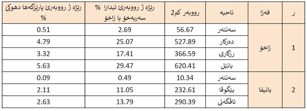
The area of Zakho Independent Administration is approximately 2,104.9 km², accounting for 19% of the total area of Duhok Governorate, which covers 11,012 km².
as illustrated in the table below.
as illustrated in the table below.
Population (Census)
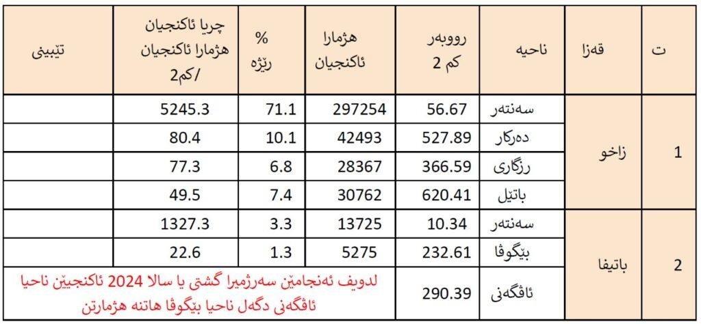
According to the results of the 2024 General Population and Housing Census, the population of Zakho Independent Administration reached 417,876 people, representing 26.11% of the total population of Duhok Governorate, which stands at 1,599,871 people.
The population is distributed between urban and rural areas, with the vast majority residing in urban centers. The urban population stands at 337,359 people, representing 80.73% of the total, while 80,571 people live in rural areas, accounting for 19.27% of the administration's total population, as shown in Table (2).
The primary reason for the decline in the rural population of Zakho is the ongoing armed conflicts between Türkiye and the Kurdistan Workers' Party (PKK) in border areas, which have led to the displacement of residents and the abandonment of numerous villages.
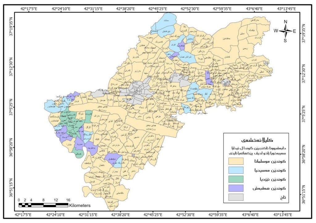
In terms of its demographic and social composition, the region has historically been renowned for its values of peaceful coexistence and mutual respect. It is home to diverse religious communities, including Muslims, Christians, and Yazidis, who live together in harmony.
As illustrated in Map (1), villages belonging to different religious communities are interspersed throughout the region. The Kurdistan Regional Government, particularly following the 1991 uprising, has placed great emphasis on strengthening this spirit of coexistence, making Zakho Independent Administration a peaceful and welcoming haven for people seeking safety and stability.
Following the events of 2014 and the takeover of several Iraqi governorates (Nineveh, Salah al-Din, and Anbar) by ISIS, Zakho Independent Administration welcomed more than 100,000 displaced Yazidis and Arabs, who were accommodated in seven camps within Zakho’s administrative boundaries.